Equestrian Trails, Inc. was established as a nonprofit corporation in 1944 with the Charter to be “Dedicated to the Acquisition and Preservation of Trails, Good Horsemanship, and Equine Legislation”.
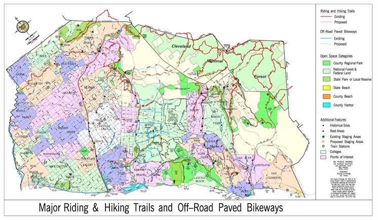
Chapter VII - Master Plan of Regional Riding and Hiking Trails
No Horsing Around
Given Orange County’s ranchero history and its cultural influence, it’s no surprise that cattle ranchers and equestrians put pressure on the Orange County Board of Supervisors to develop more horseback riding trails.
“The (trail) plan was mostly precipitated by a coalition of equestrian groups whose members realized they were losing trails because of the rapid urbanization of Orange County,” recalls Dick Ramella, who prepared the county’s first Master Plan for Regional Parks in 1963. “The equestrians had a motive for a trail system that no one else had. They were losing places to ride. Back then, there was no recreational system in place for public riding and hiking, only O’Neill and Irvine regional parks. I do not recall support for the plan coming from any walking or bike riding groups.”
Dick spent 14 years in the county’s planning department and worked closely with John Lane, the planner tasked with developing the trails aspect of the Master Plan for Regional Parks, to whom he refers as “the father of the trail plan.”
“There was an old cowboy, Gail Harmon, who bugged John to no end about the riding trails,” Dick adds. “Gail met with John daily to make sure the plan was making progress while also providing John with the information needed to prepare the plan from an equestrian perspective, such as how wide trails should be and how far apart the rest stops should be. Gail would also go to the Board of Supervisors’ office and harangue the board members to make sure they stayed behind the plan and making progress.”
While equestrians, planners and the Board of Supervisors backed the 1965 Master Plan of Riding & Hiking Trails, many residents opposed the plan. “There were questions about construction and maintenance costs, security, safety and privacy,” Dick says. “It was not an easy plan to develop, implement or build. The county did not have a parks department at the time, which meant we did not have anyone to implement the plan once it was adopted. That was a problem.”
Eventually, George Osborne, chief engineer of the Orange County Flood Control District, jump-started the Master Plan of Riding & Hiking Trails by developing the county’s first recreational trail along the Santa Ana River. Today, the Santa Ana River Trail & Bikeway crisscrosses into San Bernadino and Los Angeles counties and through the Orange County cities of Yorba Linda, Anaheim, Orange, Santa Ana, Fountain Valley, Costa Mesa, Huntington Beach and Newport Beach. A variety of geography and park opportunities makes the Santa Ana River Trail one of the county’s most popular trails. Activities on and along the trail include hiking, bicycling, walking, running, rock climbing, geocaching, bird watching and horseback riding.
Also known as the Crest to Coast Trail, the Santa Ana River Trail is 60 percent complete with plans to finish the remaining portions within the next five years. When it is finished, the Santa Ana River Trail will be the longest multi-use trail in Southern California: from Big Bear Lake, high in the San Bernardino Mountains, to the Pacific Ocean. According to the site santaanarivertrail.org, the trail “passes through urban parkland and through quiet willow forests. It skirts some of the region’s most vital, exciting cities and passes under giant cottonwood trees.”
Although the Santa Ana River Trail and many other county trails have morphed into multi-use corridors, Jeff says they were only proposed for horseback riding and hiking. “Jogging was not popular back then and there were no road bikes or mountain bikes like we have today,” he explains.
Our club advocates for trail access. We submitted a letter in response to the request for comments to the Resource Management Plan (RMP).
Read it here!

Click here for more information on other OCTA acquisitions in Orange County.
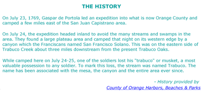
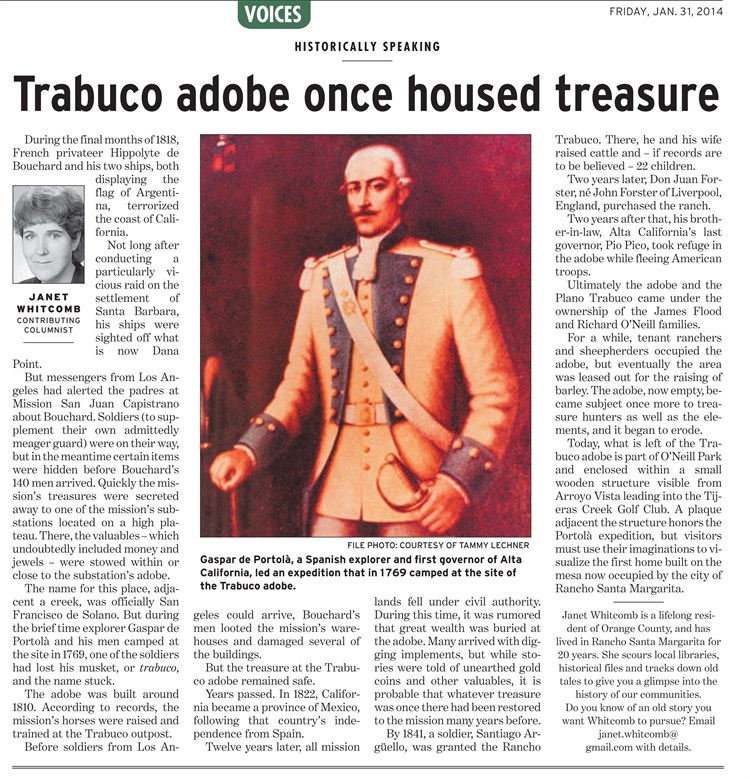
Here's some Trabuco Canyon history...