We do trail maintenance in O'Neill Regional Park the EVEN months of the yean! Join us! Contact our Activities Director...
- Trail Maintenance in O'Neill Regional Park
Harmon Equestrian Area:
No Horsing Around
Given Orange County’s ranchero history and its cultural influence, it’s no surprise that cattle ranchers and equestrians put pressure on the Orange County Board of Supervisors to develop more horseback riding trails.
“The (trail) plan was mostly precipitated by a coalition of equestrian groups whose members realized they were losing trails because of the rapid urbanization of Orange County,” recalls Dick Ramella, who prepared the county’s first Master Plan for Regional Parks in 1963. “The equestrians had a motive for a trail system that no one else had. They were losing places to ride. Back then, there was no recreational system in place for public riding and hiking, only O’Neill and Irvine regional parks. I do not recall support for the plan coming from any walking or bike riding groups.”
Dick spent 14 years in the county’s planning department and worked closely with John Lane, the planner tasked with developing the trails aspect of the Master Plan for Regional Parks, to whom he refers as “the father of the trail plan.”
“There was an old cowboy, Gail Harmon, who bugged John to no end about the riding trails,” Dick adds. “Gail met with John daily to make sure the plan was making progress while also providing John with the information needed to prepare the plan from an equestrian perspective, such as how wide trails should be and how far apart the rest stops should be. Gail would also go to the Board of Supervisors’ office and harangue the board members to make sure they stayed behind the plan and making progress.”
While equestrians, planners and the Board of Supervisors backed the 1965 Master Plan of Riding & Hiking Trails, many residents opposed the plan. “There were questions about construction and maintenance costs, security, safety and privacy,” Dick says. “It was not an easy plan to develop, implement or build. The county did not have a parks department at the time, which meant we did not have anyone to implement the plan once it was adopted. That was a problem.”
Eventually, George Osborne, chief engineer of the Orange County Flood Control District, jump-started the Master Plan of Riding & Hiking Trails by developing the county’s first recreational trail along the Santa Ana River. Today, the Santa Ana River Trail & Bikeway crisscrosses into San Bernadino and Los Angeles counties and through the Orange County cities of Yorba Linda, Anaheim, Orange, Santa Ana, Fountain Valley, Costa Mesa, Huntington Beach and Newport Beach. A variety of geography and park opportunities makes the Santa Ana River Trail one of the county’s most popular trails. Activities on and along the trail include hiking, bicycling, walking, running, rock climbing, geocaching, bird watching and horseback riding.
Read the whole story about County trails...
Vista Trail:
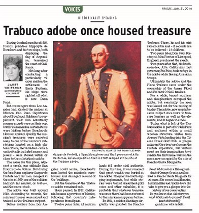
Arroyo Trabuco: